
When Does The Heat Wave End For The Coast
Gulf Shores News Staff • August 23, 2026
Sweating out the summer in Gulf Shores

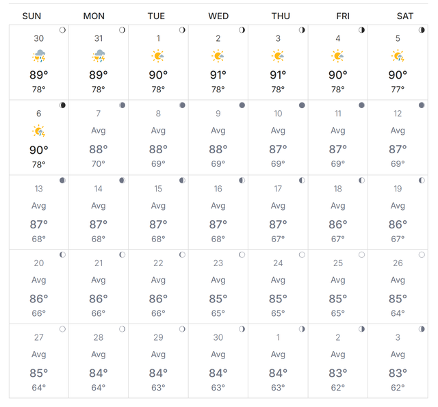
Gulf Shores, Ala. — (GSN) — The intense August heat wave that has gripped Gulf Shores is finally showing signs of winding down. After reaching high temperatures in the mid 90's, temperatures are forecast to begin a gradual downward trend. Highs will drop below the 90-degree mark to around 89°F on Tuesday, and continue to cool to 85°F by Friday. While daily highs for the rest of August are expected to range from 85°F to 94°F, the general downward shift represents a break from the peak of the late-summer heat.
This cooling trend comes as a welcome relief after a massive and stubborn atmospheric pattern known as a "heat dome" stalled over the southern and southeastern United States throughout much of August. This high-pressure system trapped scorching hot air and high humidity over the region, sending temperatures climbing into the 90s and triple digits, with dangerous heat index values regularly exceeding 105°F to 110°F. The heat dome is projected to stay over the southern U.S. through the end of August, but will slowly deamplify and transition as the region enters September.
Looking ahead past Labor Day (September 7, 2026), Gulf Shores will transition to more comfortable, late-summer weather. According to historical weather data for Gulf Shores and Orange Beach, the normal daily high for September is 85.4°F, with a normal low of 73.8°F, yielding a comfortable monthly average of 78.6°F. Following Labor Day, daily high temperatures are forecast to settle consistently into a range between 84°F and 87°F, while overnight lows will cool to between 72°F and 76°F. This gradual cooling marks a comfortable end to an exceptionally hot summer season.
Please keep this quote in mind when talking about our coastal weather:
The weatherman is always right. It's just his timing that's off.
September Temperature Forecast























Recent Posts