Why the Most Severe U.S. Hurricanes Strike After Summer
R. Peevy • August 13, 2026
Severe gulf hurricanes typically make landings in fall months

Gulf Shores, Ala. — (GSN) — While the Atlantic hurricane season officially begins on June 1, the most active and destructive period for tropical cyclones occurs deep into the season, spanning from mid-August through mid-October. Although summer heat peaks in July and early August, the oceanic and atmospheric ingredients required for major hurricanes do not fully align until late summer and early fall.
The primary driver behind this delay is the thermal mass of the ocean. Water retains heat far longer than air, requiring months of continuous summer sun to warm the deep tropical waters to the 26°C (79°F) threshold necessary to fuel intense storms. Sea surface temperatures usually reach their maximum in late August and September.
Additionally, atmospheric dynamics become much more favorable during this period. Vertical wind shear—the abrupt change in wind speed and direction with altitude that can tear developing disturbances apart—is traditionally strong in May and June but fades to a minimum by late August. When this low wind shear combines with peak ocean temperatures, maximum atmospheric moisture, and a cooling upper atmosphere that creates greater instability, tropical waves moving off the coast of Africa can rapidly organize and intensify into major hurricanes. Furthermore, the dry, storm-suppressing Saharan air layer that blows across the Atlantic during the early summer typically peters out by late August, clearing the path for storm development.
REALATED ARTICLE: Historic Hurricanes Which Impacted Alabama's Coast
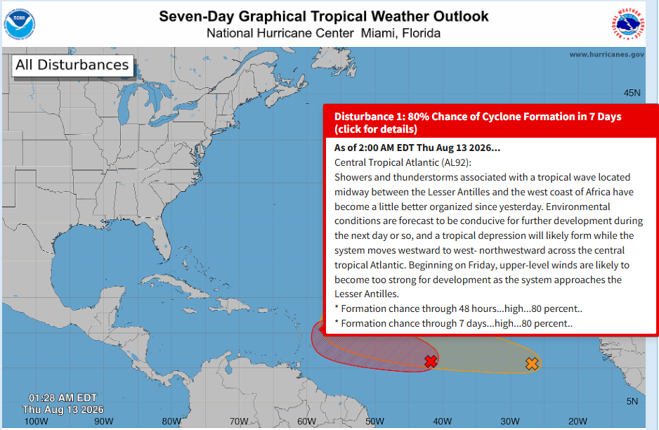
As the 2026 hurricane season progresses through this pivotal month, meteorologists continue to monitor active disturbances. Currently, the National Hurricane Center is closely monitoring a tropical wave in the Central Tropical Atlantic designated as Invest AL92. This system has become significantly better organized, with showers and thunderstorms showing clear signs of development. Forecasters have assigned this disturbance a high probability of 80% for forming into a tropical depression within the next 48 hours as it moves westward across the open Atlantic, making it the most significant system currently under observation in the basin.























Recent Posts