Gulf Shores City Council Adopts Plan To Expand Walking Area Overlay District
R. Peevy • September 15, 2026
City Council expands the walking district
Gulf Shores, Ala. — (GSN) — Gulf Shores City Council voted to suspend the rules of procedure and formally adopt Ordinance 2228. This zoning text and map amendment expands the city's Walking Area Overlay District to promote pedestrian-oriented, mixed-use commercial development near the beachfront core while establishing protections for existing homeowners.
The expansion builds upon long-range planning initiatives, including the 2005 "Envision Gulf Shores" policy document and the 2014 "Vision 2025" plan. City leaders sought to address a growing trend of lower-density single-family homes and cottage subdivisions encroaching into commercial zones around the intersection of Gulf Shores Parkway and Beach Boulevard.
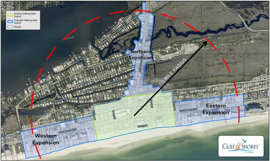
The expanded overlay district boundaries are calculated using a half-mile (10-minute) walking radius from the central beach intersection:
- Westward Boundary: Extends to Sixth Street (Windmill Ridge).
- Eastward Boundary: Extends to the block between Third and Fourth Streets.
- Northward Boundary: Reaches north to Waterville, encompassing Business Tourist (BT) zoned properties.
Core Overlay Regulations and Incentives
The Walking Area Overlay District applies supplemental regulations alongside underlying zoning:
- Mandatory Active Ground-Floor Uses: Standalone residential structures are prohibited. All new residential or lodging developments must dedicate at least 10% of their ground-floor space to commercial or active non-residential uses (such as shops or dining).
- Incentive-Based Density and Height: The district does not grant "by-right" height or density increases. Developers may petition the City Council for height and density bonuses in exchange for providing public benefits, such as public parking or enhanced beach access.
- Parking Flexibility: Mixed-use projects can seek parking reductions through site-plan level demand studies.
Residential Protections: The Savings Clause and CUP Process
To protect existing homeowners within the district, Ordinance 2228 updates Article 13 of the zoning ordinance by broadening the "savings clause":
- Legal Non-Conforming Status: Reclassifies 56 existing single-family structures (25 in the original district and 31 in the expanded boundary) as legal non-conforming uses.
- Reconstruction Rights: Allows property owners to rebuild their homes to original gross floor area if destroyed by natural disasters or catastrophic events.
- 50% Improvement Limit: Restricts structural expansions or renovations to 50% of the home's market value, though standard maintenance (e.g., roofing, painting, flooring) is excluded from this cap.
- Conditional Use Permit (CUP) Path: Property owners seeking additions beyond 50% value or custom rebuilds can apply for a Conditional Use Permit through the City Council without incurring extra site plan fees.
As communities navigate the rapid rise of electric bikes, motorized scooters, and golf carts, the revival of dedicated walking districts highlights a fundamental need for balance on shared pathways. While micro-mobility offers convenience and alternative local travel options, preserving safe, walkable areas remains essential for pedestrian safety and community life.
By pairing speed regulations and clear usage boundaries with designated pedestrian zones, municipal planning can foster an environment where modern transportation and foot traffic coexist harmoniously. Ultimately, prioritizing pedestrian-focused districts ensures that even in an increasingly motorized era, human-scale connectivity stays at the heart of public spaces.



















Recent Posts